Perhaps its just me, but every trip to the battlefield seems to answer some questions. However for every question answered two more are raised. And that is what happened on a recent trip to Spotsylvania.
UPDATED with new video. Today we did validate that this section of line was not shown on either the 1916 nor the Surviving earthworks maps.
http://www.youtube.com/watch?v=MccRHXf2bzo
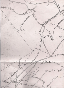
From a 1916 map of the property owned by the Battlefield Land Co. Done by the Chief Surveyor of the city of Fredericksburg.
Above you see a section of the map done in 1916. An examination of this map shows earthworks which, sadly, no longer exist. In addition it shows the roads which existed at the time as well as saw mill seats. So in effect we have a snapshot of what was done during the war as well as development since. A snapshot not taken in the heat and confusion of a battle.
Now I had always believed, and been led to believe that there was only one surviving section of Confederate picket line out in front of Doles Salient. A short section just about 20 yards or so inside the historic wood line of 1864. This section was just to the left of the trail and ran along a low ridge until it petered out on the high ground overlooking a “dry weather branch”. And if memory serves that it was supposedly built after Upton’s charge on May 10.
http://www.youtube.com/watch?v=YOjg3RylEm8
The late Bill Matter and I didn’t do much exploring out there in front of the works but we did find a few remnants, all to the left of the road. Again we believed that there was nothing to the right of the trail.
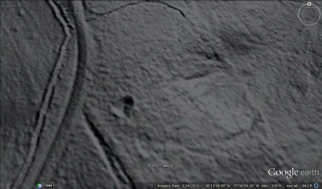
Well, not so fast. On this last trip one of my goals was to shoot a video of the entrenched line left of the road. Having done that, on a whim, I decided to look one more time to the right of the trail. And lo and behold, hiding in plain sight was a line of works about 30 yards further into the woods, along the trail, and on its right side!
http://www.youtube.com/watch?v=eG_AL6QRrEk
You perhaps can see that these works are ditched on the side toward the Confederate line as you would expect. What you wouldn’t expect is that the extreme right hand end, from the Confederate point of view, curls forward toward the Federal line. So now we have a line which extended further across the Confederate front than we previously believed.
HOWEVER, I draw your attention again to the 1916 map at the top of this article. Find the road which leads out from the Confederate works at Doles Salient. Then follow it away from the works until just before you reach a dogleg in the road at a saw mill seat. Notice that there is a line of Breast works running perpendicular to the road on its left side. Also note that there is nothing shown on the right hand side.
So, did the map maker and his team miss that line of works all together? Or is the real question the location of the road?
And of course the obvious question which is who built both lines, when were they built, and why they don’t line up with each other?
What do you think?

 However, this is not the case at all. All five of the artillery battalions spent some time along the lines of either Rodes or Johnson’s divisions. Generally speaking after two days they were replaced by another battalion. These reliefs were generally, although not always, made in the early morning hours.