Over the last few posts I have shown various videos of a line of works out in front of the area between the west Angle and Doles Salient. These works, to the right of Upton’s trail, have evidently escaped mapping at least as far back as 1916.
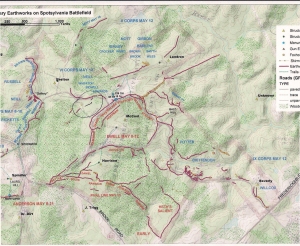
So in an effort to put a location with the video, I have included this scan of the “Surviving Earthworks on Spotsylvania Battlefield” map. If you will notice between the area of the Shelton house, to the left of center midway up the page, and the Confederate line, marked Daniels, Hays, Walker, etc, you will see a circle drawn on the map. Inside there is a short line drawn with blue pen denoting the approximate location of this line.
Please note the use of blue pen is not to signify that it was Federal, but rather to make it stand out from the other works in red.
http://www.youtube.com/watch?v=MccRHXf2bzo
Above is again the last video taken of those works. Now to see if we can find some more information on them .
After looking at the GPS plot on the map, it appears that this stretch of line (approx 217 feet in length) was actually aligned with the section on the other side of the trail. And that perhaps the reason for the bend on the end is to incorporate it into the spur which leads from the Federal line and across the park road. That is just a hypothesis at this point however. If so why was the spur down slope? The reason which jumps to mind is for shelter from Confederate fire from the area near the West Angle. The Confederates themselves, remarked that it was worth a mans life to go for water on the 11th.


Where did you get the map of “Surviving Earthworks on Spotsylvania Battlefield” That would be great to have when I do not have my Hess to carry around.
Stephen Keating
LikeLike
Stephen
Thanks for checking the blog out. The map you refer to was done by the National Park Service in the early 2000’s. I got my copy from the gentleman who was in charge of that project. Don’t know if it is available anywhere else. I have left him a message about releasing his name.
However, if you give me your address I can make a copy and send it to you.
Hope you are finding the subject interesting.
Russ
LikeLike
Can you send me an email direct, so I don’t put my address here on the site?
LikeLike
Stephen
Will do using my yahoo account.
LikeLike
Thanks
LikeLike