The beginning of IF

I have been working on an article about the events of May 11 and into the wee hours of May 12. Having just finished the first draft and started the editing process I wanted to share some portion of it. Afterwards I will focus on the editing as well as the inclusion of maps, sketches,photos etc.

IF

Prologue

First let me say that what follows is not the story that typically comes to mind when people think of the Battle of Spotsylvania Courthouse. It’s not about the twenty odd hours of hand to hand fighting by men standing in muddy trenches firing under splintered headlogs, or around the end of traverses which ran along a nondescript ridge in the middle of Spotsylvania County one rainy day in May 1864.

Instead it’s the story of the events on the Confederate side during the roughly twenty-four hours before that. Decisions made by men who were veterans at their craft, based on the sketchiest of information on which thousands of lives depended. Action and reaction, the story of the men who attempted to carry out their duty and its result.

The Beginning

Like so often after a battle the morning of May 11th brought rain to the part of Spotsylvania County around its Courthouse village.  Rain during this part of year would hardly be a surprise to natives of the area. Native Virginians have long known of what they call “the long spell in May”. This period of sometimes daily rain lasts for approximately ten days near the middle of May, It provides a boost for crops and raises the water table in preparation for the hot dry summer months ahead. This year however was different. For this year it fell, not just on farmers and small shopkeepers but on two great armies. Armies who had come to Spotsylvania County as part of the struggle which would decide the fate of the continent. The weather only added to the misery and difficulties of troops and animals exposed to it.  Movement might or might not be affected or prevented.  Trenches could become mudholes and parapets become piles of mud. Pulling loads became even more difficult for the animals, who had to endure not only the excruciating drudgery but the treatment of masters who far too many times bordered on cruelty. Temperature differences could cause fog, and that could conceal one’s enemies. The rain as well as fatigue from the exertions limited the days fighting to skirmishing and sharpshooting. The sharpshooters while annoying were generally not dangerous as long as the troops could sit in the trenches. But movement outside of them was at one’s peril. The simple act of going for water could cost a man his life. But none of this could be allowed to stop the armies in the pursuit of their objective. The burden must be borne if ones side was to emerge victorious.

The ease with which the Federals had broken Maj. Gen. Robert Rodes line on the evening of May 10, had come as an unpleasant surprise to Gen. Robert E. Lee. Shortly after the Federals under Col. Emory Upton had been forced to withdraw from the Confederate line that evening Gen. Robert E. Lee had sent a message to the commander responsible for the defenses there. That man Lt. Gen. Richard S. Ewell’s vaunted Second Corps, which still proudly associated itself with the late Stonewall Jackson, held a large salient north of the Brock Road. In his note Lee bluntly ordered Lt. Gen. Ewell to find a way to prevent the Federals from repeating the success. Lee believed that Upton had found it too easy to break over the line around Dole’s salient. (A1) In orders unusually specific for Lee, Ewell was given direction in the most basic matters for a commander, to make sure that junior officers resupplied and reorganized their men to be ready to renew the fight.  But he also showed a knowledge of the weaknesses of the defenses of the area in question. As a result, Ewell was instructed to either have a ditch dug outside the works or find a way to enfilade the field with artillery. Either of these two methods, one active the other passive, would contribute to disrupting and slowing an attacking force. (a2) While we cannot today reconstruct the process by which Ewell and his staff chose a plan of action, we can look at what they did or didn’t do. Then by process of elimination perhaps we can see why. Evidently Ewell found the idea of digging a ditch unappealing. There was already a farm road which ran from where the road from the Harrison House crossed Rodes line at Doles Salient towards the Landram House. When the Confederates had formed their defensive line they left the road immediately in front of it. That combined with an abatis should suffice as a passive measure to slow the attackers. The field to the left of the apex of Doles Salient was already covered by artillery fire from two batteries. So how about the other proposal, to enfilade the field? Certainly, there was no need to employ more artillery from the left, or Brock Road side of Doles Salient. To the right of the point where the Harrison House road crossed the works the ground sloped down and away for several hundred yards. This wasn’t suitable for the employment of artillery for several reasons First the slope to the right made the placement of artillery challenging. Guns placed there could fire straight ahead if level pits were prepared to allow accurate aim. But they would be so close to the crest and the way the ground sloped away limited the field of fire. Lee had recognized this and called for the enfilading of the field which obviously meant from the right. At first blush this didn’t appear practical because of the woods and terrain. But a closer examination showed that there was high ground several hundred yards to the north. This part of the line, which was occupied by Walkers Stonewall Brigade was also where there was a slight bend in the line beyond the lane from the McCoul house. From there it would be possible for artillery to place enfilading fire across the field. First however an intervening neck of pine trees which led out from the Confederate lines would have to be cut down. During the night a detail of men from the Stonewall Brigade, armed with axes was sent out to accomplish that task.

Posted in 1864, American Civil War, artillery in the Overland Campaign, Battle of Spotsylvania Courthouse, Battle of the Muleshoe, Bloody Angle, Doles Salient, Earthworks and trenchs, field fortifications, Hancock's assault on the Muleshoe, Johnson's Division, May 12, Mule Shoe, Overland Campaign 1864, Uncategorized, Upton's Charge | Tagged , , , , , , , , , , , , , , , | Leave a comment

The route back to camp


1916 red overlay on LIDAR

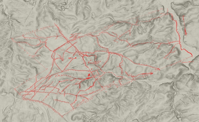
The works laid out in red overlaid over the terrain taken from LIDAR


We do not know exactly the route that the artillery took as it marched back to its camps. However, as we know the starting, midpoint and destinations we can make a very good hypothesis as to the route they took. Particularly since security was a primary goal. One of the primary obstacles to a withdrawal was Meadow Run which flowed between steep banks eastward from the McCoul spring.  It is certainly possible that roads had been cut through the woods and military bridges laid across the stream.  However two farm lanes already crossed the stream and ran out to and beyond the Confederate defenses. One ran toward each face of the salient. Regardless of whether they had been bridged before the troops arrived, any competent commander would have ensured that the stream was passable even if it might be difficult. Because of security it is likely that both battalions left their positions and moved eastwards behind the works, taking advantage of whatever concealment, the terrain offered until they reached the east McCoull Lane. They would then have followed this across the Run, past the McCoull House then followed the road past the Harrison House. At least one of Pages Batteries, the Morris Artillery, under Captain Montgomery, stopped at the Harrison House. They were told they were to move on to their camp. They would have continued following the lane which ran southeasterly in the direction of the Courthouse. Entering the woods near where work on a new defensive line had begun they came to a fork in the road. Pages battalion would have turned right and quickly reached the Brock Road. They would have reached the road almost opposite the path leading to the house of J.Trigg. This was near the western edge of a large cleared space which extended several hundred yards eastward. Nelson’s battalion could have continued straight ahead at the point where the road divided.  That would have taken them out to the Brock Road at a point several hundred yards closer to the Courthouse. They could then have followed this road until they reached a point where they could turn off to the right to go behind the Village. There amongst some orchards behind the village they found the battalion camp.


Posted in 1864, American Civil War, artillery in the Overland Campaign, Battle of Spotsylvania Courthouse, Battle of the Muleshoe, Earthworks and trenchs, field fortifications, Hancock's assault on the Muleshoe, Johnson's Division, May 12, Mule Shoe, Muleshoe, Overland Campaign 1864, Page's Battalion, Reese's Battery | Tagged , , , , , , , , , , , , | Leave a comment

A comment on a portion of the Campbell Brown Papers

In the Campbell Brown papers he leaves us a description of a meeting at the Harrison House on the afternoon of May 11, 1864. Supposedly Gen. Lee orders the guns removed from the salient at this time, and for the reasons listed. The first two paragraphs are written based on Maj. Browns account. After that I take a look at the meeting and offer a slightly different view.

Late in the afternoon Gen. Lee presided over a gathering of many of the senior officers of the Second Corps. These men, according to Maj. Campbell Brown, came together at the Harrison House near the center of the salient. At the time this was the site of Gen. Ewell’s headquarters. (a15) Among those present were Generals. Lee, Ewell, Long, Rodes and their staffs. Obviously this wasn’t a council of war as neither Maj. Gen. Johnson nor Gen. Gordon, commanding two of the three divisions of the corps were present. Nor apparently was Col. Thomas Carter who was supposedly in command of the artillery within the salient. Likely they were occupied along their lines at the time of the gathering. (a16)

Some accounts by private soldiers along the lines of Rodes division claim that the officers were visible outside in the yard. Also that occasional overshoots by Federal artillery interrupted the proceedings. During the gathering couriers from the scouts and skirmishers were continually bringing in reports. They generally were reporting that the enemy appeared to be withdrawing the artillery and trains. As the meeting continued the idea that the Federals were withdrawing toward Fredericksburg gained credence among those present. That came to be the belief of Gen. Lee himself. He also noted that no enemy had yet appeared in front of Gen. Johnson’s line. (a17) Accordingly, he ordered Genls. Ewell and Long respectively to withdraw both Johnson’s infantry and the artillery supporting it. This would allow both the men and horses to be fed and rested prior to a move. (a18) Gen. Ewell responded that given the fact that the evening was very wet, that the men had their shelters prepared, that they would be more comfortable in the trenches than out in the open. Gen. Lee agree and gave his permission for the infantrymen to remain in their positions. However, the orders for Gen. Long to remove the artillery directly supporting Johnson’s division stood. Those batteries would be withdrawn to graze and rest the horses. (a19)


 Maj. Brown’s account gives valuable insight into the thoughts of the Confederate command that afternoon. Yet a examination of the facts suggests that it should not be taken literally. While Lee was likely anxious to remove his troops from what he felt was a dangerously exposed position this was hardly the time to do so. Indeed, where would they be moved to? There were, to this writer at least, only two realistic options for a move. Either withdraw the men to a line that had been started earlier in the day which ran along the high ground behind the Harrison House or perhaps to reoccupy Gordon’s line. Neither one of these were attractive as the first was incomplete while Gordon’s line had already been proven vulnerable to Federal artillery fire. That fire, which raked it from end to end, had forced the evacuation on it shortly after it was built. These thoughts of course presupposes that Lee was not planning on assuming the offensive, nor was there conclusive evidence that the Federals were indeed moving.

As for moving the artillery supporting Johnson’s line that was also not entirely the case. By having Gen. Long remove the battalions of Nelson and Page he removed those battalions dedicated to Johnson’s direct support. However, Cutshaw’s battalion while supporting both Johnson and Rodes was physically located within Johnson’s lines. Thus, technically should have been included in Lee’s instructions. Yet, as we shall soon see, there was no intention of withdrawing his battalion nor Hardaway who was supporting Rodes. Rather both battalions were to march with the infantry when it moved. This writer’s opinion is that, almost exactly like the evening preceding the movement from the Wilderness, plans were being made for the infantry to be accompanied by a modest force of artillery. The rest would proceed separately and minimize disruption. By moving separately, they would not slow the progress of the infantry.  Or, perhaps lessons had been learned the previous day. Then artillery withdrawing from exposed positions along the West Face of the salient had delayed and disrupted troops trying to move across the salient to join in the counterattack.


Posted in 1864, American Civil War, artillery in the Overland Campaign, Battle of Spotsylvania Courthouse, Battle of the Muleshoe, Cutshaw's Battalion, Earthworks and trenchs, field fortifications, Hancock's assault on the Muleshoe, Johnson's Division, May 12, Mule Shoe, Muleshoe, Overland Campaign 1864 | Tagged , , , , , , , , | Leave a comment

Another little segment

The movement of Hayes men to Johnson’s left caused other problems for the Confederates as well. Ideally Johnson would have just shifted the brigades of Witcher and Steuart to the left to cover the gap. But that was not practical in this case. There was no connection between Johnson’s right and the left of Wilcox’s Third Corps division. Instead there just a skirmish line of one regiment, the 21st Va. from Witcher’s brigade across the gap. If the gap was to be closed at all, the Third Corps would have to do it. Accordingly later in the day Lane’s North Carolina brigade was moved from its position near the brick kiln to the divisions far left overlooking Meadow Run. The brigade commander Brig. Gen. James Lane, saw an opportunity to fulfill his mission while using a shorter line. Receiving permission from Wilcox he extended his left down to and across the marshy ground near the Run.

IMG_20170411_1335055

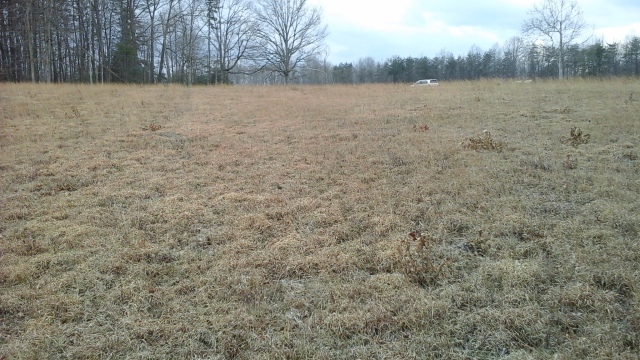
Looking from the original line of  Confederate works along the high ground left of the toe out toward the Landram House site.

Posted in 1864, American Civil War, artillery in the Overland Campaign, Battle of Spotsylvania Courthouse, Battle of the Muleshoe, Earthworks and trenchs, field fortifications, Hancock's assault on the Muleshoe, Johnson's Division, Jone's Brigade at Spotsylvania Courthouse, May 12, Mule Shoe, Overland Campaign 1864 | Tagged , , , , , , , , , | Leave a comment

See We Really Have Started

A little tease to show we really have begun. But this is just the introduction. The rest is much larger. Not Gordon or Bill but pretty inclusive.

20170324_141516

Looking across Reese’s Salient as it appears today. Looking toward the direction the Federals would have made their approach.

A deafening quiet settled over the little salient. Of course quiet was a relative term. There were still scattered rifle shots whether from nervous infantrymen close by, or just some anonymous noise off in the distance. None of that even registered on the clusters of men gathered around the cannon they served. Two of them had just finished firing at a group of Federal infantry which had appeared in their front and quickly fell back out of sight to avoid the storm of canister fire which had been sent their way. Even though there were no more targets visible activity still surrounded the guns. Two of which sat with a light cloud of steam rising as the morning dew evaporated from them. There had only been a few moments for the men to relax and savor the fact that, for the moment it was over. For most of these men were veterans of quite a few fights like this. They knew from experience that they needed to quickly prepare in case action had to be resumed. Guns had to be reloaded and pushed back through the mud into position, then re-sighted at the most likely point that the enemy could reappear. Debris had to be cleared away from around the gun so that they didn’t have to worry about tripping or being obstructed in a time when seconds might mean life or death. Only then would they be able to relax, maybe get a smoke if they had any tobacco.
 While this was going on the men around the other two guns of the battery, who because of the shape of the line hadn’t had a target, offered a running commentary of advice or criticism. Some kept a lazy lookout in the event that the enemy should appear. Others found a way to avoid the sergeants desire to keep them busy, or simply relaxed in the quiet of the cold miserable morning. Still others, perhaps a little wiser, fidgeted with the guns, making sure that they were in as good a order as possible.
 Back just behind the little position, still smaller groups of men fussed around the four caissons. Counting how many rounds had been used, making sure that there would be no delay in selecting and providing whatever type of round the Corporals at the guns wanted when they called for it.
Posted in 1864, American Civil War, artillery in the Overland Campaign, Battle of Spotsylvania Courthouse, Battle of the Muleshoe, Bloody Angle, Carrington's Battery, Earthworks and trenchs, field fortifications, Hancock's assault on the Muleshoe, May 12, Mule Shoe, Overland Campaign 1864, Page's Battalion, Reese's Battery | Tagged , , , , , , , , , , , , , , | Leave a comment

We begin Anew

Really owe everybody an apology for not doing anything for an extended period of time. Think that somewhere between the illness and the resulting treatment my passion slipped away. While speaking with a friend today I realized it hadn’t gone away just needed rekindling. So I’m going to get back at it. This time I will focus more on telling the story instead of just on the factoids.

First, we won’t be writing about dogs but every time I see this picture of Sadie I smile and remember the good times and that feels good

Sadiebeinghappy

So now we begin again.

Posted in Uncategorized | Leave a comment

Test page

this is only a test page

1916 map with LIUDAR jpg


1916 red overlay on LIDAR


Posted in Uncategorized | Leave a comment

LIDAR overlaid with 1916

Thanks to my friend Ted Linton who was able to work his computer magic I think we have a treat for you.

1916 red overlay on LIDAR

1916 Map overlaid onto the LIDAR . Notice the roads that didn’t exist in 1916 which show up on lidar. 

As I have commented in the past there are features  which existed in the Salient area at least as recently as 1916 which are no longer visible. We know this because a map was created for the Battlefield Land Company in 1916 which shows them.

Remember that 1916 was before either the CCC or National Park Service was involved with the property. So it is very doubtful that there were any “improvements” or “enhancements”done. However there were a large number of sawmills scattered about the property. These are clearly shown on the overlay, and give us some idea of the man made activity that was occurring at the time. Also it seems likely that anything in the immediate vicinity was likely damaged or destroyed. The process of getting men, animals, and timber to and from these sites was probably  extremely invasive. And it was likely done with little if any concern to whether damage was done to vestiges of “the war”. By the nature of the business these sites probably existed for quite some time in a multitude of places. Once the timber close to a site was consumed a new site would be opened. To this writer its seems that the timber buisness may have altered the landscape more than the traditional agriculture.


So what you see below is the 1916 map overlaid onto the LIDAR photo from 2014.  There may be some slight differences of a few feet either way because of referencing. Unfortunately you may have to look closely to see the newer features, as only they will not be covered by the 1916 map. Also keep in mind that the 1916 map is of the property owned by the Battlefield Land Co. That company did not own the entire battlefield so does not cover the entire page.

cut1overlaid

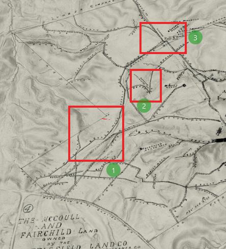
(1) the jog in the line no longer exists. This is probably where Jones battery was and perhaps a brigade boundary. (2) either agricultural needs or the CCC cut a gap in the works here. Colonel Alexander tablet? (3) notice when the west McCoull lane cuts thru the works it jogs left then goes straight before turning right toward the Landram House.


errors, or perhaps the 1916 map is slightly off. But see how things have changed .

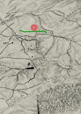
cut2overlaid

(1) the east McCoull lane . The likely routeat least for  part of the way for Page’s guns on the morning of May 12.

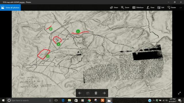
lidaroverlaid

in its entirety. (4) is an area of interest. Today a shallow line of works straddles the walkway leading out from Doles Salient to this line of works. In 1916 the road went past the end of the works. Which made sense because it avoided the drain. So the walkway has been moved.


Enjoy. It has come to my attention that viewers using an Android phone or tablet can tap on the photographs and zoom in to get a better view. Unfortunately Windows users can not. That’s something I need to work out with WordPress. My apologies.


Posted in 1864, American Civil War, artillery in the Overland Campaign, Battle of Spotsylvania Courthouse, Battle of the Muleshoe, Bloody Angle, Earthworks and trenchs, field fortifications, Hancock's assault on the Muleshoe, Johnson's Division, May 12, Overland Campaign 1864, Richmond Howitzers, Upton's Charge | Tagged , , , , , , , , , , , | Leave a comment

“Dont move until the infantry does”


Of all the events during the Overland Campaign of 1864 those of May 12 at Spotsylvania stand out. Perhaps the only true rivals for the title of the most significant event of the campaign are Grant’s decision not to turn back from the Wilderness and his bloody repulse at Cold Harbor on June 3.

IMG_20170411_1335055

Looking from the Confederate works toward the Landram House site in the distance. Carrington thought that guns should be moved in the night to cover this ravine.

The events of that have been discussed ever since. First by the participants themselves, primarily on the Confederate side, later by historians as well as enthusiasts. Most people accept the premise that it was the weakness of the defense near the apex of the Salient that morning which gave the Federals the opportunity. A weakness primarily because the artillery, present until just the evening before, had been withdrawn on Lee’s instructions. (1) General Lee himself took the blame on himself for making that decision. Post war many Confederates officers publicly echoed that opinion. Many claimed that if the artillery had been in place the Federals would have suffered a bloody repulse that morning. Thomas Carter, who had overseen the battalions which were withdrawn,  offered perhaps the strongest view of what he felt would have happened. Writing to Major John W. Daniel on October 11, 1904 he stated “I never saw a long line of artillery with open ground in front as much as 400 yards, for double canister to have its full sway, and put in its perfect work, carried by front attack. No matter how many lines of battle came against it: and my belief is that it would be as impregnable against front attack as the Rock of Gibraltar with a pocket pistol”. (2)

What is seldom mentioned is that there was artillery in the area that morning. However, it was not positioned to successfully contest the assault. How they came to be there and the decisions that were made regarding them is one that needs to be told.

artillery511earlyam

Artillery dispositions morning of 5/11/64. (1) Page’s battalion (3) Nelson’s battalion (4) Garber’s battery (5) Braxton’s battalion in reserve (6) 3 of Hardaway’s batteries in reserve or refitting (7) 2 of Cutshaw’s batteries not yet committed (8) Jone’s battery of Richmond Howitzers, Hardaway’s battalion off photo toward the Brock Road

On the morning of May 10, 1864, a rotation of artillery units along the fronts of Rodes and Johnson’s divisions was performed. Braxton’s and Page’s battalions had marched with the infantry from the Wilderness. The remaining three battalions had been withdrawn to a staging area at Verdiersville the night before the army marched. They then moved by a separate route before rejoining the infantry outside Spotsylvania Courthouse. Braxtons battalion was withdrawn from the line and placed in reserve. Hardaway’s battalion, or 3 batteries of it, took positions along the line of Rodes’s division. Pages battalion moved from Rodes line into position along the right of Johnson’s division. Nelson’s battalion upon its arrival near Johnson’s center or along the left of the apex of the salient. Cutshaw’s battalion began arriving near the Courthouse.

Posted in 1864, American Civil War, artillery in the Overland Campaign, Battle of Spotsylvania Courthouse, Battle of the Muleshoe, Bloody Angle, Carrington's Battery, Cutshaw's Battalion, Doles Salient, Earthworks and trenchs, field fortifications, Hancock's assault on the Muleshoe, Johnson's Division, May 12, Mule Shoe, Overland Campaign 1864, Richmond Howitzers, Tanner's Battery, West Angle | Tagged , , , , , , , , , , , , , , , , | Leave a comment

Who was Colonel Alexander? (updated 5/31/17 and 6/10/17)

One of the fascinating things about the Battle of Spotsylvania Courthouse and its aftermath is the amount of things that we have no answers to.

One of them is a simple straight forward question. Who was Colonel Alexander? Now of course most of the men who fought here did so anonymously. So what prompts me to ask the question?

scan1916map2

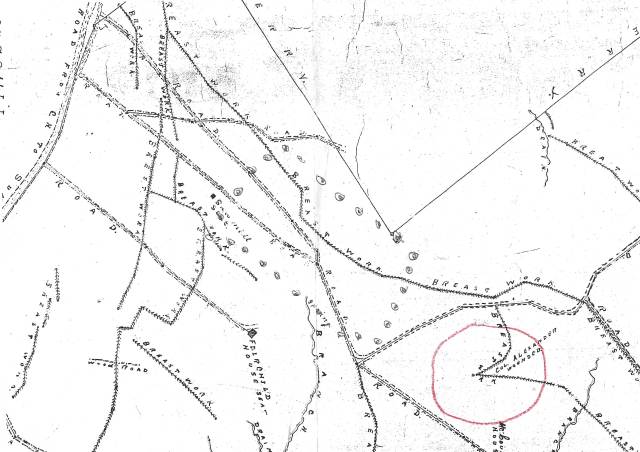
In 1916 the mapmaker marked the spot at the junction of the re-entrant and second lines. Why?

In 1916 a map was prepared by Mr. E. H. Randall who was City Surveyor of Fredericksburg and Deputy Surveyor for Spotsylvania County. The map, certified on 16 March, 1916 showed “The McCoull and Fairchild Land owned by the Battlefield Land Company.”

While interesting in its own right its true significance in my opinion is it shows us things which are now lost. For example a jog in the Confederate line between Doles Salient and Brock Road which is no longer visible, even with LIDAR. Sawmill seats, as well as other smaller breastworks. Certainly worthy of a careful study.

ice_screenshot_20170531-180532

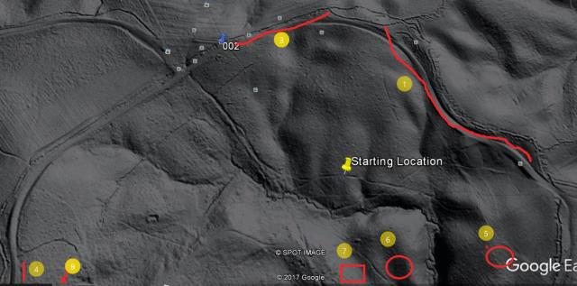
(1) section of trench on Daniels left which is shown on 1916 map, no longer visible (2) heavily eroded, or perhaps partially leveled trench. Probably Ramseur’s Brigade area. (3) left of Gordon’s line

But if one looks at the point (which I have circled in red) on the scan above we see a mystery Mr. Randall left us. At the junction of the  re-entrant line and the Confederate second line is the note “Col. Alexander wounded”. So who was Col. Alexander? How would the surveyor know that he was wounded there? And why would it have been included on his map?

The most reasonable explanation is that someone had previously placed some type of marker there. There was such a marker on the east face of the salient, placed by two officers from the 10th Virginia, noting where General Steuart was supposedly captured. Is this something similar? And if so who placed it?

IMG_20170610_1343535

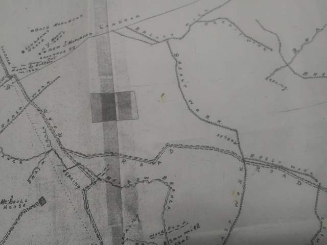
This section of the 1916 map shows the wooded tablet placed by officers of the 10th Virginia. Meant to commemorate the spot where General Steuart was captured. Note that it is simply marked “Tablet”.

Note that on the map, even though the tablet identified its purpose, it simply says “Tablet”. What is different? One would think that if both spots had markers they would be shown similarly.


Mr. Noel Harrison, a very knowledgeable historian and veteran of the National Park Service, suggests that perhaps “Colonel Alexander” is a corruption of the name of General Alexander Webb. General Webb was seriously wounded in front of the second line on the morning of May 12th, 1864. This certainly cannot be ruled out, although if true the placement does appear to be a little close to the Confederate line.

20170212_151053

Taken from the second line just to the right of where the note “Colonel Alexander wounded” was placed. Note how far down the reverse slope. This ground was heavily fought over on the 10th , 12th, and to a lesser extent the 18th.

We don’t know which side Colonel Alexander fought for, nor what day he was wounded. After all in addition to the constant sharpshooting, this ground was fought over on at least three different occasions. On May the 10th, Upton’s charge surged across this sector, then was thrown back by Confederate counterattacks. On the 12th the Federals charged up this hill from their breakthrough near the apex of the salient, before falling back. Several Confederate brigades as well as artillery batteries moved across this field as they moved to the attack or in support. Lastly on the 18th Federal troops moving forward to attack Lee’s final line crossed this area. So in short it could have happened at any point during the battle.

Then of course, it could simply have been a case of post war self promotion, or veteran organization rank.


Posted in American Civil War, Battle of Spotsylvania Courthouse, Battle of the Muleshoe, Doles Salient, Earthworks and trenchs, field fortifications, Hancock's assault on the Muleshoe, Johnson's Division, May 12, Mule Shoe, Muleshoe, Overland Campaign 1864, Richmond Howitzers, Upton's Charge | Tagged , , , , , , , , , , , , , , | Leave a comment